
Another Winter Storm Hits the Eastern US
Parts of the United States are still recovering from last weekend’s winter storm, which dumped over 20 inches of snow in some areas. Thousands of flights were canceled, hundreds of thousands lost power, and multiple fatalities were reported.
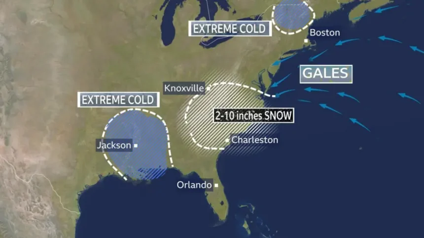
This weekend, a new system is forming off the southeastern coast. While it may not be as widespread as the previous storm, the Mid-Atlantic and far northeastern states are expected to experience further snowfall and strong winds.
Arctic Air Brings Record-Cold Temperatures
Bitter Arctic air continues to grip much of the eastern US, stretching as far south as Florida. Temperatures are forecasted to drop as much as 15C (59F) below average. Florida’s Panhandle has already seen frosts of -5C (23F), and Ohio reported lows of -27C (-17F).
Snow and ice on the ground are unlikely to melt, making the region vulnerable to new snowfall. Experts warn that this cold spell could be the longest-lasting in decades.
How the Bomb Cyclone Will Develop
The storm will begin forming near the Gulf Coast on Friday, moving across the southern Ohio and Tennessee Valleys with a mix of rain and snow. By Saturday, it will rapidly strengthen over the Atlantic, creating a ‘nor’easter’—a powerful low-pressure system that brings strong winds, heavy snow, and coastal hazards.
Winter storm watches have been issued for northern Georgia, South Carolina, eastern Tennessee, North Carolina, and southern Virginia. Snowfall could reach up to 15 inches (38cm). Coastal areas may also face storm surges and blizzard conditions, which could lead to power outages and dangerous travel.
By Sunday, the storm may move north, potentially affecting major cities such as New York and Boston. However, there is some uncertainty about whether it will stay offshore.