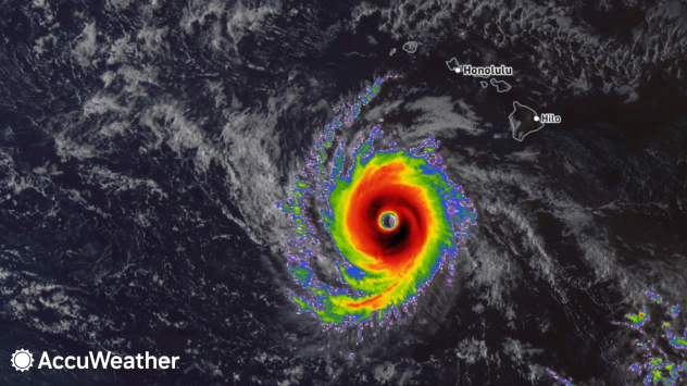
Hurricane Nolo strengthened into a major Category 4 hurricane on Sunday, Sept. 27, as it moved southwest of the Hawaiian Islands. AccuWeather reported maximum winds of 155 mph, with the storm remaining offshore and avoiding a direct landfall.
The storm has still brought heavy rain, strong winds and dangerous surf to parts of Hawaii. Officials say the immediate flood threat is decreasing as Nolo moves away, although strong gusts and large waves remain a concern.
Quick Fact
| Quick Fact | Details |
|---|---|
| Storm | Hurricane Nolo |
| Strength | Category 4 hurricane |
| Date | September 27, 2026 |
| Location | Southwest of the Hawaiian Islands |
| Maximum Winds | 155 mph |
| Distance from Honolulu | About 405 miles southwest |
| Landfall | No direct landfall on the main Hawaiian Islands |
| Heaviest Rainfall | 21.99 inches reported in Laupahoehoe |
| Main Risks | Heavy rain, flooding, strong winds and large waves |
| Latest Status | Nolo is moving away from Hawaii |
Hurricane Nolo Reaches Category 4 Strength
Nolo became a Category 4 hurricane on Sunday as it traveled west northwest southwest of Hawaii. AccuWeather reported that the storm was about 405 miles southwest of Honolulu on Sunday night, with maximum winds of 155 mph.
The storm’s center stayed south and southwest of the main Hawaiian Islands. That kept Nolo from making a direct landfall while still allowing its outer effects to reach parts of the state.
Heavy Rain Hits Hawaii
The Big Island and Maui received some of the heaviest rainfall linked to Nolo. AccuWeather reported that several locations on the Big Island received more than 12 inches of rain.
Laupahoehoe recorded 21.99 inches, according to the report. Parts of northern Maui also received more than a foot of rain on the northeastern slopes.
Rain was expected to increase across the western islands as Nolo turned north. AccuWeather forecast another 1 to 2 inches of rain from Tuesday into Wednesday, with higher totals possible in mountainous areas.
Wind gusts of 40 to 60 mph were possible from Maui to Kauai, with stronger gusts at higher elevations. Such winds can damage structures and bring down trees and power lines.
The Hawaiʻi Emergency Management Agency said large and damaging waves remained possible along parts of the Big Island coastline. The agency advised people to stay away from dangerous shoreline areas and continue following official weather updates.
What Officials Said
AccuWeather Hurricane Expert Alex DaSilva said:
“Due to flooding rainfall, mudslides and damaging winds, Nolo is a 2 on the AccuWeather RealImpact™ Scale for Hurricanes in Hawaii.”
The RealImpact Scale considers several factors, including wind, flooding rain, storm surge and economic damage. It differs from the Saffir Simpson Hurricane Wind Scale, which measures hurricane intensity based on wind speed.
Hawaii Faces Another Tropical Threat
Nolo is the latest in a series of tropical systems to affect Hawaii during the 2026 hurricane season. AccuWeather reported that the state has experienced more tropical threats than usual this year.
The season has included Hurricane Lala, Tropical Storm Moke and Hurricane Lowell. AccuWeather also linked the active pattern to strengthening El Niño conditions and unusually warm ocean waters.
Hurricane Lala caused extensive damage on the Big Island in August. Some communities lost power for an extended period after the storm passed offshore.
Latest Status of Hurricane Nolo
The latest Hawaiʻi Emergency Management Agency update says Nolo is moving away from the Hawaiian Islands. The agency said heavy rain and flooding threats were decreasing, but strong and gusty winds could continue across the state.
Large waves also remained possible along parts of the Big Island coastline. Residents and visitors were urged to avoid flooded areas and dangerous surf while monitoring official forecasts.