
South Florida is starting October with heavy rain, thunderstorms and gusty winds. Several areas have already received multiple inches of rain, raising concerns about street flooding and ponding.
The National Weather Service has also warned of minor coastal flooding and a high risk of rip currents along Atlantic beaches. These conditions could continue into the weekend.
Quick Facts
| Detail | Information |
|---|---|
| What happened | Heavy rain and thunderstorms affected South Florida. |
| Location | Miami Dade, Broward and other parts of South Florida. |
| Date | Thursday, October 1, 2026 |
| Rainfall | Some areas received several inches of rain. |
| Flooding Risk | Localized street flooding and ponding remain possible. |
| Coastal Risk | Minor coastal flooding may occur around high tide. |
| Beach Conditions | High risk of rip currents along Atlantic beaches. |
| Forecast | Showers and thunderstorms may continue into the weekend. |
Heavy Rain Triggers Flooding Concerns
Heavy rain and thunderstorms rolled over South Florida on Thursday. The National Weather Service reported heavy rainfall and storm activity over the region.
Heavy rains impacted highways and towns in Miami Dade and Broward counties, prompting a flood advisory. Fort Lauderdale, Pompano Beach, Hollywood, Weston, Miami Gardens, and Miami Shores had heavy rain.
Rainfall amounts reached several inches in some areas. According to reports, there was around 3.5 inches near Aventura and close to 3 inches in sections of Fort Lauderdale, Plantation, and Coral Springs. North Miami received around 2 inches.
King Tides Add to the Coastal Flooding Risk
Higher-than-normal tides are causing more anxiety for coastal towns.
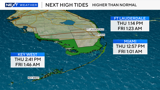
According to the National Weather Service, modest coastal flooding may occur around high tide along the South Florida coastline. Rainfall can impede drainage in low-lying locations.
On Thursday, high tides occurred in Fort Lauderdale, Miami, and Key West. Coastal areas may experience flooding on certain low-lying roads and houses at these times.
Dangerous Rip Currents Expected
Beach conditions are also a key issue.
The National Weather Service has declared a high danger of rip currents for Atlantic beaches in Palm Beach, Broward, and Miami Dade counties. The warning will remain in effect until Saturday evening.
Strong easterly winds are causing difficult conditions along the shore. Boaters may also experience higher waves and harsher winds.
More Rain Could Continue Through the Weekend
Rain chances will stay high through Friday and into the weekend. However, the National Weather Service predicts that the weather pattern will gradually return to a more usual late-rainy season setting.
Some storms may continue to provide significant rain to specific areas. Sunshine could become more regular during the weekend, and temperatures might reach 90 degrees.
According to the most recent local forecasts, no tropical threats are likely to strike South Florida in the next days.
South Florida Faces Coastal Flooding Risks
Coastal flooding issues may resume around high tide, and severe rip currents are forecast to persist into Saturday evening.
South Florida is experiencing a damp and unsettling start to October. Heavy rain has already raised localized flooding fears, and king tides and strong coastal winds are exacerbating the situation.
Rain and storms are expected to persist throughout the next few days. Coastal towns and beachgoers should be informed about current weather conditions and marine alerts.